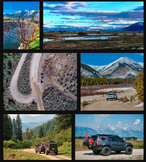
The Grand Staircase-Escalante National Monument is a vast swath of public land located in south-central Utah. Many phenomenal overlanding routes exist within the monument's boundaries. Denine and I traveled along the Hole in the Rock Road (HITR). This 60-mile rough, dirt road somewhat follows the original trail set forth by Mormon Pioneers in the 1800's while seeking a viable route for establishing a new settlement in southeastern Utah. Today, the road meanders and intersects numerous awe-inspiring canyons and narrow hold-your-breath slots. These provide for an ideal overland adventure.
"How far until camp?" Denine asked. "Ahh...We'll continue down a bit and camp at a spot I know. Maybe another 15 miles or so," I replied. Denine hadn't previously wandered in this canyon country. I had visited the Escalante wilderness numerous times prior, so I reveled in experiencing the wonders of this exquisite land through a first timer's eyes. Denine repeatedly commented on the vastness and openness of the country while petting my dog Ruby, sitting on her lap. An occasional cow ambled across the road as we surveyed 50 Mile Mountain to our south.
I stopped the Land Cruiser 200 after we crossed another dry wash when we spotted the mountain lion roughly 100 yards away. I grabbed my camera; but with the wrong lens attached, I didn't get a picture. Oh, well. We recorded the sighting in our minds. "There's the place." I said while pointing to our camping spot--Chimney Rock.

This roughly 150-foot high sandstone monolith towers over the vast Escalante wilderness. We set camp in short fashion, prepared dinner, and started the fire. We expected my friend, Shane, to rendezvous with us. I had just poured my second glass of wine when Shane arrived. We stoked the fire and placed a couple of fresh logs on it as we caught up about life happenings. I couldn't help but notice the countless stars in the enormous desert sky. With the embers doused, we crawled off to our tents for a good night's rest.
After breakfast, we jumped in our Toyotas and headed toward adventure. HITR road serves as the main artery within the Escalante canyons. It's a high desert road that terminates at an actual hole in the rock. Pioneers blasted this hole so that they could descend to the Colorado River, float across it, and continue onward to the southeastern corner of Utah. This HITR road follows somewhat of the same trail the pioneers blazed and is signified with wooden, brown posts. Today, this road allows access to the many canyons that make this land of such wonderment.
The Bureau of Land Management (BLM), who oversees the monument has a done an excellent job of marking the major turns, and soon I spotted the sign for the turnoff. We followed the 40-mile Bench Road as it wound its way across the desert plateau. Many of the side roads and spurs can be sandy, so I was glad that I brought my ARB Tred Pro traction recovery boards. At the trailhead, we prepared our packs with food and essentials. To appreciate this canyon country, we had to immerse ourselves in the canyons, so that was our plan.

As we set off on foot, a few cumulus clouds floated overhead in the otherwise blue sky. We descended down a sandy hill. Our conversations shifted between life's realities and the delights and splendors of exploring canyon country. Within 30 minutes, we stood atop a canyon's edge and stared off into the enormous canyon of the Escalante River.
We felt small and insignificant in comparison to the vast canyon and the river's tributaries. The Escalante River is one of the most remote rivers in the US. Lined with cottonwood trees and willows, the banks create a sandstone oasis. We found a path through the sandstone rock and descended to the waters of the Escalante.
We let our feet touch the cool waters, then waded through the ankle deep river. Ravens swooped in the air and an airline high overhead streaked through the sky. The joys of canyon country are simple. It was just us and Mother Nature. Shane, a professional photographer, set up for a photoshoot while Denine investigated the arch we spotted around the corner. I reclined on the slickrock and soaked up the final rays of sunshine before it set behind the high canyon walls. We hoofed it upward 500-feet to attain the canyon rim once again. From the canyon rim, we spotted Fifty Mile Mountain in the distance, which was also the direction of our vehicles. Onward. In an hour, we reached our vehicles, sat in our camp chairs, reminisced about our day over beers, chips, and salsa.
While talking, a few gentlemen asked for our help with a vehicle concern. Their vehicle would start, but the battery would soon die. The alternator wasn't working. Mud, dirt, and grime got in the alternator after several puddle crossings and caused the malfunction. The HITR road becomes muddy when rains hit in a squall, and flash floods temporarily alter the landscape!
If I can get it to town, I will replace the alternator. The vehicle owner stated. So, you are going to replace it, for sure? Shane and I double-checked. 'Yep.' With that assurance, Shane grabbed a hammer and banged on the alternator. After a few forceful hits, the alternator 'jumped' to life. The owner and his friends were ecstatic. They followed us out and down the road.
We turned off toward Chimney Rock, while they continued to Escalante. The stars 'danced' once again across the otherwise black sky. In the evening chill, we appreciated the warmth of our juniper-wood fire. The desert was calm that night and the embers burned out with a pleasant glow.

The following morning we packed camp and drove south along the HITR road. With mud puddles dried, travel was easy. We passed the HITR historical site. This enormous sandstone alcove is where in 1879 pioneers spent their time while the actual construction and blasting of the trail continued down to the Colorado River. I imagined kids playing and socializing within the enormous sandstone alcove and adults conversing once the kids laid in bed. Simpler times maybe but not necessarily easier times. The 'trail' was completed in January, 1880; and the pioneers descended roughly 1,200 feet to Colorado River.

We stopped short of the actual hole in the rock and prepared for another day-hike into a canyon. Shane packed his camera and gear, while Denine and I prepared lunch for a picnic later. My dog, Ruby, lead the way while we all followed. The canyon started simple and shallow. But, as we descended, the walls rose dramatically. Within 30 minutes, the walls towered hundreds of feet above us. Water flowed from the natural springs; and within a quarter of a mile, formed into a small, pleasant stream. Cottonwoods, golden in color, lined the stream. It appeared humans planted the trees because their symmetry was aligned perfectly with the stream. Mother Nature would have been random.
Whenever I find water in the deserts of Utah, I immediately look for signs of the Ancient Ones. Native Americans wandered this land for thousands of years. Their dwellings and rock art cover the southern Utah landscape. "What are those?" I asked Denine. "Look, there's an arch on the canyon rim." Our timing couldn't have been better. On a smooth sandstone wall below the arch, we saw an enormous rock art panel. Petroglyphs (carved pictures) covered the wall. Hundreds of petroglyphs!

"I see one, wait there's one behind it." Denine said. This panel appeared to have older petroglyphs etched into the wall and with a new panel etched sometime later. Crazy! We would see one, then refocus to see an older one. Weathering over hundreds of years had taken their toll on the etchings, but hundreds of them still appeared. The huge alcove next to the wall probably housed the Anasazi who used to call the canyon home some 800 years ago.
We ate our lunch streamside and speculated about the lives of the Ancient Ones. What was their livelihood like? How did they find food? What did petroglyphs symbolize? We had many questions, but few answers. Just speculations. No matter, the canyon "was ours" for the day. We continued hiking and admiring the grandeur of canyon country. The stream flowed to the waters of Lake Powell, but the sun was low in the sky and it was time to return to my Land Cruiser. Reluctantly, we turned back toward the trailhead.
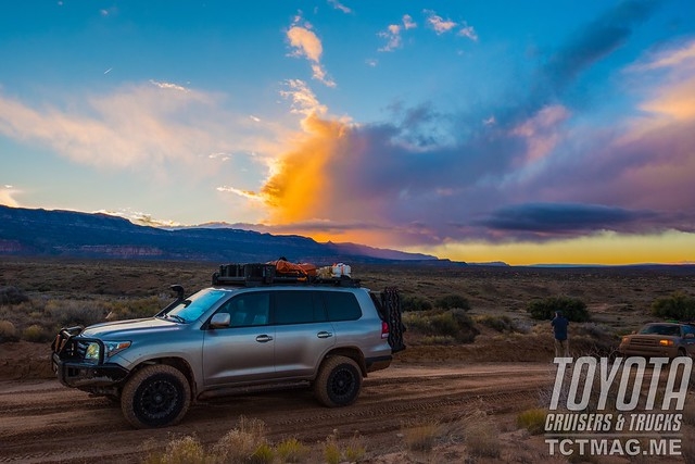
Ruby led the way as magic hour hit canyon country. Streaks of red and orange "painted" the Escalante landscape. We used the solar shower to wash up and afterward, enjoyed a few pilsners. Life was simple, but life was grand. I steered my Land Cruiser 200 toward the small town of Escalante. Shane was lucky enough to stay out in canyon country for a few days longer. The HITR Road is a gateway to canyon country splendor. However, just don't drive the road. Get out and wander on foot. The sheer natural beauty will astound and delight you. I drove the Land Cruiser onto pavement and aired up my tires for the trip home. Now, it's your turn to make the trip.
Considerations: Many routes in the Grand-Escalante Staircase are remote. Be self-sufficient and prepared to wait for help. Extra food and fuel is essential. A stock four-wheel drive vehicle equipped with good tires can conquer most the routes and roads. Traction boards like the ARB Tred Pro are an essential piece of equipment for the many sandy stretches of road. Hiking:The Grand Staircase-Escalante National Monument beckons the explorer on foot. Whether following a trail or wandering the landscape, you will be rewarded. Peekaboo-Spooky Slot Canyon-a tight, hold your breath slot. This loop hike is splendid. An enjoyable family-friendly hike. Coyote Gulch-a popular hike, usually a backpack that has jaw-dropping scenery all around. Tall canyon walls, enormous alcoves, and picturesque waterfalls make this a must do excursion. The Volcano-this stunning hike beckons the hiker to wander on slickrock to a natural depression filled with sand. No, it's not a volcano. It's a natural wonder!
To get your copy of the
Spring 2019 Issue:


Follow us on Facebook, Twitter, and Instagram to get up-to-date industry news, events, and of course, amazing adventures, stories, and photos!